2040 Temperature Check on One of North America’s Biggest Watersheds

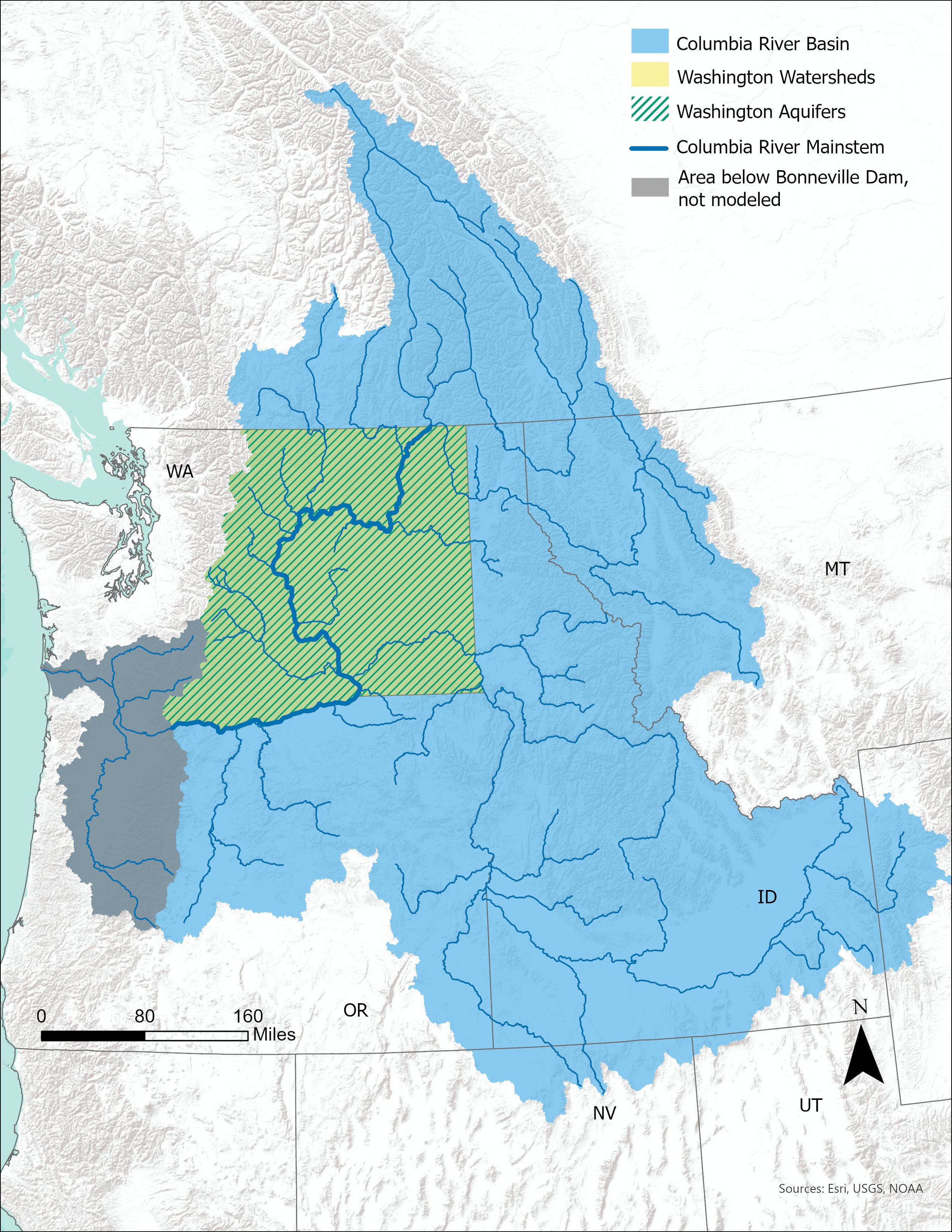
More water earlier and less snow – the Columbia River Basin’s water health was recently forecast into 2040 as the result of a two-year study across the Washington State Department of Ecology, Washington State University, University of Utah, State of Washington Water Research Center, and Aspect Consulting in the 2021 Long-Term Water Supply & Demand Forecast.

Photo Credit: Robyn Pepin, Aspect Consulting. Columbia River near Entiat

This mammoth water evaluation project – done every five years since 2006 – looks across the Columbia River Basin, which includes 34 eastern Washington watersheds. Hydrological modeling, economic modeling, regulatory context, remote sensing, surface water and groundwater monitoring and more all are studied to predict the future of water for agriculture, population growth, and instream flow health under a changing climate in this critical basin.

Forecast Insights for the 4th Largest Watershed in North America

Image Source: 2021 Columbia River Basin Long-term Water Supply and Demand Forecast

The Columbia River Basin is the 4th largest watershed in North America, running down from headwaters in Canada and mainly into four states – Washington, Oregon, Idaho, and Montana. Some notable details and insights from the recent forecast include:

  • Wet months getting 15% more water and dry months getting 28% less water

  • Earlier planting dates and more heat stress during the hot months

  • 17% higher population growth across Washington state leading to increases in demand for residential water and hydroelectric power

  • Trends in groundwater levels across the last 20 years were predominantly declining across the basin. The steepest declining trends correspond with the most heavily pumped layers and areas such as the Grand Ronde aquifer in the Odessa Sub Area and the Wanapum aquifer in parts of the Yakima Basin and Horse Heaven Hills.

Expected changes that will influence future water supplies and demands. These expected trends inform the scenarios explored in the 2021 Forecast.

Graphic Source: 2021 Columbia River Basin Long-term Water Supply and Demand Forecast

A 2040 Water Crystal Ball: Water Retiming Means More Water Earlier

Among the many takeaways in this report is the impact of climate change on water cycles. Chief among those is the prediction that peak surface flows – that feed the historically typical April – October agricultural season – will begin earlier, thus leaving less water available later in the summer when demand for that water is higher. Snowpack – the Pacific Northwest’s natural water reservoirs – will likely melt earlier because of warmer temperatures.

This ripple effect will influence agriculture starting earlier in the growing lifecycle; instream flow challenges with higher temps for fish habitat; and populations in arid regions will likely be incrementally more dependent on groundwater to serve future water supply. Declining groundwater trends mean that alternative water supplies may not be available in some areas so additional solutions are needed.

Time (in years) until the average available saturated thickness has declined by 25% in at least one aquifer layer in each groundwater subarea.

Image Source: 2021 Columbia River Basin Long-term Water Supply and Demand Forecast

State-of-the-Science Research

Aspect teamed with the project team and the scope of the science and monitoring over the last two years is impressive. A team of scientists and engineers looked at remote sensing and telemetry data across eastern Washington; climate change forecasts; population growth projections; well logs; and water rights. Some of the months-long study details of that include:

  • Integrated hydrological, river operations, crop production, and municipal, domestic and industrial water demand modeling in 34 watersheds under 34 potential climate change scenarios

  • Groundwater level trend analysis on 670+ wells

  • Automated well log review of over 4,000+ well logs

  • Manual well log review of 300+ well logs

Learn more also at WA Ecology’s project StoryMap here.

How SNOTEL Sites Show Our Water Future 2022 Part 2: Halfway Through the Water Year

It has been a rollercoaster of unpredictable weather in the Pacific Northwest so far in water year 2022, yet as of early May, the snowpack remains above normal at 107 percent.

Aspect staff monitoring water levels along the Cedar River in western Washington.

In early May 2022, we’re officially more than halfway through the ‘Water Year’, which starts counting on October 1. This is also the time we typically reach maximum snowpack depth and begin the period of springtime run-off as warmer temperatures and longer hours of sunlight transport the snowpack stored in our mountains downstream into lower basins. If you’re outdoors right now in the PNW and looking near a river or stream, you’ll notice a robust color and churn in the water that only happens this time of year– that is born from the melting snow rushing down into lowland regions.

How is the PNW Water Year Looking in Spring 2022?

Relentless weather cycles have guided our snowpack through periods of below- and above-normal times, resulting in an exciting and volatile track of the 2022 SNOTEL data. Let’s take look back at how we ended up here.

An early trend of warm temperatures and atmospheric rivers in fall 2021 delivered an abundance of rain across Washington state. However, the warm temperatures and exceptional torrents of rain stunted the initial snowpack development state-wide, bringing worries of yet another below-normal snowpack. By early-December, the snowpack was at a dismal 40 percent of normal across the Pacific Northwest Region.

Figure 1. Snow Water Equivalent in Pacific Northwest Region. The black line shows 2022 SWE trends to date. The green line shows normal “median” snowpack blue and red lines show the max and min (% median). 

Then, cold temperatures accompanied by snow in mid- to late-December 2021 rocketed the snowpack on a trend well above normal. On January 8, 2022, the snowpack was nearly 140 percent of normal – a dramatic comeback from the previous month. Still, the uptrend was short lived and by mid-January and into February, the snowpack growth plateaued.

So Far, Is the Snowpack Feeding Our Water Needs?

Part 1 of this blog series ended with snowpack right near historical normal values. Since then and into spring, we’ve witnessed wild swings in weather resulting in uncertain snowpack conditions. We ended April with colder than average temperatures slowly reviving the snowpack and bringing it once again back above normal.

In Washington, most basins remain above normal, with the central Puget Sound basin leading the state with the highest snow water equivalent values, at 136 percent of normal to date. Only the Lower Yakima basin is below normal, at 90 percent.

Figure 2. Snow Water Equivalent in Washington . As of early May 2022, most basins are above normal.

Not all regions in the western US are faring well in the battle against below normal snowpacks. Zooming out, the northern states of Washington, Montana, Idaho, Oregon, and Wyoming all have snowpacks near or above normal while Nevada, Utah, and Colorado face below normal snowpack and challenging hydroclimate conditions ahead.

Figure 3. Snow Water Equivalent in Western US basins. Most basins to the north are above normal while basins in the south continue to struggle.

SNOTEL Forecast Secrets Unpacked

This two-part blog series that put a magnifying glass on 2022 Pacific Northwest snowpack shows how water supply from our largest and most valuable reservoir is constantly changing.

A useful key to forecast the security of our water supply and adapting to the everchanging conditions is the integrated network of nearly 300 SNOTEL climate monitoring stations scattered across the state.

Forecasting Washington’s water future is vitally important as communities, farmers, industries, and habitat all depend on this resource when the ‘reservoir’ stored in the snow transforms into streamflow that replenishes river and groundwater basins

The Path to Professional License: Isabellah von Trapp, LG

In the science and engineering industry, seeing a “PE”, “LG”, “PMP”, or other initials behind someone’s name shows that person went through years of work experience that culminated in a substantial test to confirm the right to practice their area of technical expertise. A professional license is a proof statement that communicates that the people charged with designing roads and buildings; solving water supply challenges; cleaning up contaminated soil and water; and successfully managing project quality are qualified and ethically accountable professionals. Many go through this licensing journey but few outside that group know what the process is really like.

We’re telling those stories here. Aspect’s professionals are writing a series of articles that capture the trials and successes of studying for and receiving these career-defining milestones.

Isabellah von Trapp, Licensed Geologist (LG)

Test taken: October 2021

Results given: November 2021

Isabellah at Mt. Rainier demonstrating how she felt when she received her LG exam results.

Where did you start with your test prep?

I got out some construction paper and my favorite markers and drew a big, beautiful geologic time scale and geologic diagrams (e.g., fault blocks, Bowen’s Reaction Series, etc.). I hung them on the wall adjacent to my desk so it would be a constant reminder to study. Helpful? Not really. But it was a nice and fun way to ease into reviewing what initially felt like a very daunting amount of material.

What were your study tactics?

Practice tests, reviewing the study guide, flipping through flash cards, desperately seeking ASBOG advice on Reddit (r/geologycareers for curious minds), etc.

Walk us through the Big Test Day…

I woke up around 8 am. The test didn’t begin until early afternoon, so I tried to sleep in as much as my body would let me. Despite the nerves and not feeling hungry at all, I forced myself to eat something. I opted for oatmeal, a clementine, and some coffee. I put on my favorite jeans (for style) and favorite flannel (for comfort). Perhaps unsurprisingly for a geology exam, the exam room, as I would later find out, was full of people in very similar outfits.

Having an intense fear of being late, I left Seattle around 9:30 am for a 1pm exam in Olympia. On the drive down I listed to all my favorite music. Upon arrival, my extra time – given the dramatically early arrival – was spent reviewing the study guide in my car. I don’t think I learned anything new at that point but it eased my mind to have one last look at things.

There was a lot of nervous energy in the exam room leading up to the test. I remember the first page of questions being fairly easy, which inspired initial confidence, but they seemingly got harder as the exam progressed. Afterwards, I genuinely felt pretty bad about the way it went. I drove home semi-deflated but happy to be done in the interim. Later that evening I met my friends at a cabin on a lake for the weekend. It was nice to get my mind off the test.

How did you feel when you got the results?

Honestly, I was shocked. One of my old college classmates took the exam at the same time. He called me one Thursday night (after I had just landed in New Orleans for a short, extended weekend vacation) to see how I did as he had just received his passing results. Anxious, I checked my email. Nothing! I refreshed my email approximately every 10 minutes for a few hours but didn’t hear anything that evening. At this point, I assumed I failed and would be a recipient of the “We regret to inform you” email the next day. Much to my delight, I got a congratulatory email and a digital copy of my newly minted license the next day. A sunny Friday in New Orleans was the perfect time and place to receive this news. You can bet I took myself out for a beer (or two) after that!

What was the best piece(s) of advice you got from others who’d done this before?

  • Life does in fact go on if you don’t pass the exam on the first try.

  • Even if you do pass, you will probably feel like you didn’t afterwards so there’s no sense in stressing during the approximate 45-day period it takes to get your results. Think “ignorance is bliss” purgatory.

What should a person gearing up to do this know about the mental, physical, and social challenges of test prep?

Depending on how you study/absorb material, you probably won’t have much of a life for a month or two leading up to the test. However, you probably will not set yourself up for success if your mental batteries are drained at the expense of your physical and social health. I think it’s critically important to give yourself a break. About 3 weeks before my exam, I skipped a weekend study session to go backpacking through the Enchantments with my friends. This was probably the best thing I could have done.  

Any parting advice for those getting ready to embark on this journey?

The LG exam is offered twice per year – once in March and again in October. If possible, try to take the exam in March so you can spend the rainy winter months inside studying instead of the coveted, sunny, August/September days. Also, have a treat on deck to enjoy immediately after the exam is finished. I did not anticipate how hungry I would be afterwards. Unfortunately, I did not heed either piece of my own advice in this instance, but that is okay. Hindsight is indeed 2020.

The Path to Professional License: Ida Fischer, PE

In the science and engineering industry, seeing a “PE”, “LG”, “PMP”, or other initials behind someone’s name shows that person went through years of work experience that culminated in a substantial test to confirm the right to practice their area of technical expertise. Many go through this licensing journey but few outside that group know what the process is really like.

We’re telling those stories here. Aspect’s professionals are writing a series of articles that capture the trials and successes of studying for and receiving these career-defining milestones.

Ida Fischer, Professional Engineering (PE) License

Test: 5/17/2021  Awarded: 6/3/2021

Ida at Rialto Beach.

When did you start with your test prep?

My PE test timeline was largely dictated by COVID. I began studying in January 2020, and was rolling along when COVID struck and everything shut down. So, I put studying on the back burner until December 2020 with the goal of taking the test before summer 2021—since I was taking the Environmental PE test, which is administered on a computer, you have to schedule it based on testing center availability (rather than the biannual pen and paper tests). I started to feel the pressure and kicked my test prep into high gear mid-March 2021.

What were your study tactics? How did you get started?

Generally, for standardized tests (SAT, GRE) I like to review testing strategies, but I couldn’t find much discussion of strategy for the PE test any other than “study as much as you can.” Taylor Dayton generously shared her study materials with me, which included a box of various books, practice tests, and some notes. I don’t have an undergraduate in engineering, so I thought a comprehensive review book was a good option to make sure I saw all the possible topics. I worked my way through the entire book (PE Environmental Review by Lindeburg), then about a month before the test, I switched to practice problems. I also used flash cards to drill general info and problem types I was consistently missing. In hindsight, I think it would have been more time-efficient to focus on the problems and then read up on topics that weren’t feeling familiar rather than reading the entire book. Problems force you to engage with key concepts in a different way.

What should a person gearing up to do this know about the mental, physical, and social challenges of test prep?

For most people, studying is a significant time commitment which will likely impact all other areas of your life. It is important to set your own expectations and get the other significant people in your life onboard with what your studying is going to look like. My studying experience was largely impacted by COVID – I didn’t have to cut back on socializing in a significant way since I was already at my maximum Zoom capacity.

Mentally, you have to find a time when you are able study productively. This will look different for everyone – I was a hybrid after work and weekend studier. Physically, I was studying while concurrently training to cycle across Washington. I think the physical activity provided an important mental break. I benefitted from multiple routine activities reinforcing each other.

Walk us through the Big Test Day…

I woke up early enough to have time to have a good breakfast and coffee and allow for traffic on the way to the testing center, but not so early that I had any time to review or extra time to work up any nerves. The Environmental PE test is administered at standard testing centers, so there is the usual review of how to check in and out and use the computer. As I was working through the problems, I kept track of the ones I was confident in, those that I was less confident in, and those that I had to guess on. I had some extra time when I was done, so I reviewed all problems I was less confident in and some of the others as well. Overall, the test felt easier than I expected. On the way home, I celebrated with a cookie. That night before bed, I did not review my flashcards and that felt like relief.

How did you feel when you got the results?

While studying for the PE exam, Ida was also planning a cross-state bike trip. She and her dad and uncle rode from Seattle to Idaho over 6 days along the Palouse to Cascades Trail and smaller country roads. This picture is on PCT either along Keechelus Lake or Lake Easton (hard to keep track on the trail). She was on the trail when she found out she’d passed the exam.

I was delighted. I did a victory cartwheel even though I had biked 70 miles that day. The test results were supposed to be ready in about 10 days, so I had been checking my email even though I was on a bike trip and generally like to eschew email while on vacation.

What lessons did you learn that you’d want others to know?

I believe I could have achieved the same result (passing) with less studying. I think I was so concerned about the possibility of not passing that I didn’t weight the opportunity cost of the amount of studying I was doing.

Washington requires an application and Board approval to even register for the test. I put this off until the 11th hour and the application process was more work than I expected and consequently more frustrating than it needed to be. I’d say as soon as you’re thinking about taking the test, get the application out of the way.

Riverbank: Quickbooks for Water Managers

Riverbank Logo.png

In ‘water-short’ basins and agricultural centers, many Pacific Northwest water managers – e.g., counties, PUDs, irrigation districts, cities --  wrestle with how to accurately measure water used to meet a range of development, agricultural, and habitat goals. In Washington State, the $300M 2018 Streamflow Restoration Act was the trigger that changed how cities, counties and others track rural water use, pushing water managers to ‘account’ for water in rural building projects and water that can be saved for fish and streams. Aspect developed Riverbank, a cloud-based water accounting application, to make it easier to manage, evaluate, and keep track of the water balance sheet.

Spreadsheets Aren’t Adequate for Managing Critical Water Use Data

Riverbank provides the transparency and reliability to radically cut the time water managers take to do water accounting math and reporting

The ‘old’ tools like Excel are ill-equipped to deal with accounting complexities such as managing different mitigation sources across drainage basins (e.g., trust water rights), and variable accounting rules/logic (e.g., consumptive use). Add to that the inherent risk of tracking mission-critical data inside a spreadsheet, and this can be a frustrating, expensive, and precarious process for a water manager trying to meet water management guidelines and business needs.

Enter Riverbank—A cloud-based application for managing the water balance sheet

The Riverbank application is a web-based accounting system that is wired into other workflows (like permitting processes and GIS) to meet the myriad reporting and planning needs that water managers have. It's tooled to the very specific conditions of water accounting at a basin-scale and developed to support the "living ledger" requirements that allow agencies to keep track of and report out on where they stand relative to resource/growth management requirements.

Riverbank provides an easy-to-use and share summary of water use accounting across subbasins and water reserves.

Water Banking and ‘Mitigation’ is the Future

Most PNW basins are over-appropriated during the summer when demand for water continues to expand and ‘mitigation’ is here to stay.  Water banking (using water stored or held in trust to mitigate for new demand) is likely the future for public agencies needing to serve additional customers (counties, PUDs, irrigation districts, cities) and for private developers wishing to  build new properties.  However, mitigation only works if it is tracked and reported.

Links for Foster and Hirst cases.

Links for Foster and Hirst cases.

Visualizing Rural Water Use in Chelan and Okanagan Counties

Riverbank provides the transparency and reliability to radically cut the time water managers take to do water accounting math and reporting. Chelan County and Okanagan County currently use Riverbank to meet permit-exempt well tracking responsibilities required by the Washington State Department of Ecology.

With Riverbank, thousands of parcels served by permit-exempt wells are tracked and visualized -- including details on associated building permits, irrigation water supplies, additional dwelling units, and more. GIS technology in Riverbank allows the system to automatically assign basin-specific accounting rules and water use assumptions to each parcel.

Contact Senior Data Scientist Blair Deaver or Associate Data Scientist Parker Wittman to learn more about how Riverbank can help you.

Building the Biggest Water Bank in Washington State

In Spring 2021, the Washington State Department of Ecology (Ecology) started the public review process for the TransAlta water bank—at 28,000 acre-feet per year, the biggest water bank in the state to date. This is the first significant water bank for Southwestern Washington and came together through years of planning, working with Chehalis basin stakeholders, and extending the water rights life of a Chehalis River hydropower project. The trigger for this new water bank is TransAlta retiring its decades-old hydropower plant on the Skookumchuck River, thus freeing up tens of thousands acre-feet of water rights for the basin.

Water banks Add Life to Thirsty Watersheds

In water-scarce basins — even on the western/‘rainy’ side of Washington State -- water banks provide an innovative mechanism to reuse water rights; once water is no longer needed for its original purpose it can be made available to meet new needs.  Water banking involves a partnership between the holders of valid water right holders and Ecology.  While the water right holder controls how new uses are permitted, the State of Washington is responsible for determining the amount of water that will be preserved, and then protecting that water from other users. 

Tranalta water bank image.png

The TransAlta water banking process has proceeded through an Aspect-led permitting path that involves an exhaustive vetting of the historical water use, and the development of a new process to guide the reallocation of future uses.  Water rights that were issued for other purposes – such as industrial supply – are converted to instream flows purposes, and generally become available to mitigate new uses.

The TransAlta water bank solution is a textbook example of how pre-planning saved a significant block of valid water rights from relinquishment for non-use.  Water that had been allocated for a highly consumptive out-of-stream use will now be held in trust for instream flows, with select new uses being reallocated for new purposes under Ecology’s permitting process. The end result will be a combination of water that will remain instream, and new water right permits for new uses.

Tapping the Skookumchuck River to Boost Chehalis Basin’s Water Future

Stretches of the Skookumchuck River, like this one taken near the City of Centralia, will soon receive more water.

Stretches of the Skookumchuck River, like this one taken near the City of Centralia, will soon receive more water.

The TransAlta water bank is situated near Centralia, Washington, along the Skookumchuck River—a major tributary of the Chehalis River. For decades, TransAlta has used the waters of the Skookumchuck to produce coal-based electrical power; however, as the company began to make plans for a life after coal, it also had the foresight to make plans for its water rights, which represents more than 50 cubic-feet per second (that is 22,500 gallons per minute) and 28,000 acre-feet per year of out-of-stream uses.

TransAlta’s retired Unit 1 of its Centralia, Washington coal-fired power plant in 2020. Unit 2 is planned to close by the end of 2025

TransAlta’s retired Unit 1 of its Centralia, Washington coal-fired power plant in 2020. Unit 2 is planned to close by the end of 2025

According to TransAlta’s Water Bank Overview FAQ, this is “enough water to fill 14,000 Olympic-sized swimming pools or irrigate 14,000 acres of farmland.”

Seeding 28,000 Acre-Feet of Water for Fish and Agriculture in the Chehalis Basin

While the budding water bank is still in the early planning stages, several new water uses have already been identified. One deal involves making water available to the City of Centralia for its future needs and to provide a source of mitigation water to offset the impacts of future private wells throughout the watershed. TransAlta also envisions making water available for the basin’s expanding agricultural needs and ensuring leftover water remains instream to protect aquatic resources.


Taylor Dayton Presenting on Washington Water Rights - April 14

Aspect Water Resources Engineer Taylor Dayton, PE, will present to the Central Washington University America Water Resources Association student professional chapter on Wednesday, April 14, 2021.

The presentation will explore the history of water law in Washington State, the process for obtaining new water right, the process for changing existing water rights, consumptive use and spreading , water right valuations, and water right holder “musts”.

See Taylor talk about what you’ll learn here:

Celebrating Key Watershed Plans in Spokane and Okanogan Basins

January 2021 launched great news for watersheds across Washington state – but first, let’s recap.

The $300 Million Watershed Law

In 2018, following water rights uncertainty that held up a $4 Billion budget in Washington State, the state passed the $300 Million Streamflow Restoration Act. The prime target was unlocking more water in a way that benefits habitat, communities, and agriculture and allows thoughtful development plans to proceed. Fast forward to 2021 and counties and basins across the state are seeing the outcomes of that law – most directly 6 out of 15 basins have updated watershed plans to date.

Status of Streamflow Restoration Grants and Planning Process
Source: Washington State Department of Ecology

Key Takeaways of Streamflow Restoration Act Results (So Far)

  1. Permit-exempt well impacts on instream flows and water right holders will be completely offset for the next 20 years.

  2. Local watershed partners have once again demonstrated they can collaborate on local solutions to water supply challenges.

  3. The plan adoption paves the way for shovel-ready projects to be implemented to benefit streamflow.

In three of those basins – Little Spokane (WRIA 55), Okanogan (WRIA 49), and Chehalis (WRIA 22 and 23) – there has been real progress on planning for the future water needs of the region. Aspect has worked for years on two of these (Little Spokane and Okanogan) and is excited to see the positive outcomes so far.

Little Spokane Watershed (WRIA 55) Plan Update

Headwaters of the Little Spokane River, near Newport, WA

Aspect has worked with Spokane County over the last several years to support watershed planning and management, including the development of watershed restoration projects. On January 28, 2021, Ecology adopted the updated Little Spokane Watershed Management Plan. This will mean:

  • Spokane County is in the process of completely offsetting permit-exempt well impacts and developing streamflow improvement projects totaling 4,085 acre-feet, including:

    • Purchasing water rights as mitigation

    • Building a Managed Aquifer Recharge project

    • Studying approaches for increasing storage in Eloika Lake to improve summer streamflows, combined with wetland and habitat enhancement

Okanogan Watershed (WRIA 49) Plan Update

Aspect has worked for years with Okanogan entities like Oroville-Tonasket Irrigation District (OTID) and others to lead up to this watershed planning update. This will mean:

  • The lead Okanogan watershed planning group -- WRIA 49 Planning Unit -- developed a two-tier list of projects to be adaptively managed to provide both consumptive use water offset and achieve Net Ecological Benefit in a manner consistent with the strong agricultural values of the community.

  • Two projects – Antoine Valley Ranch and Methow Beaver Project’s Restoring Streamflow after Wildfire in Okanogan and Methow River Subbasins – have been funded by Ecology and will be the first projects implemented following the adoption of the plan.