Why a Record-Breaking Winter Doesn’t Solve Western Water Issues

Did this year’s record-breaking snowpack officially end the megadrought? (Spoiler alert: it did not.) What solutions exist to face the challenges of western water management?

 Animas River in Durango, Colorado flowing in May 2023

A Record-breaking Winter in Western US

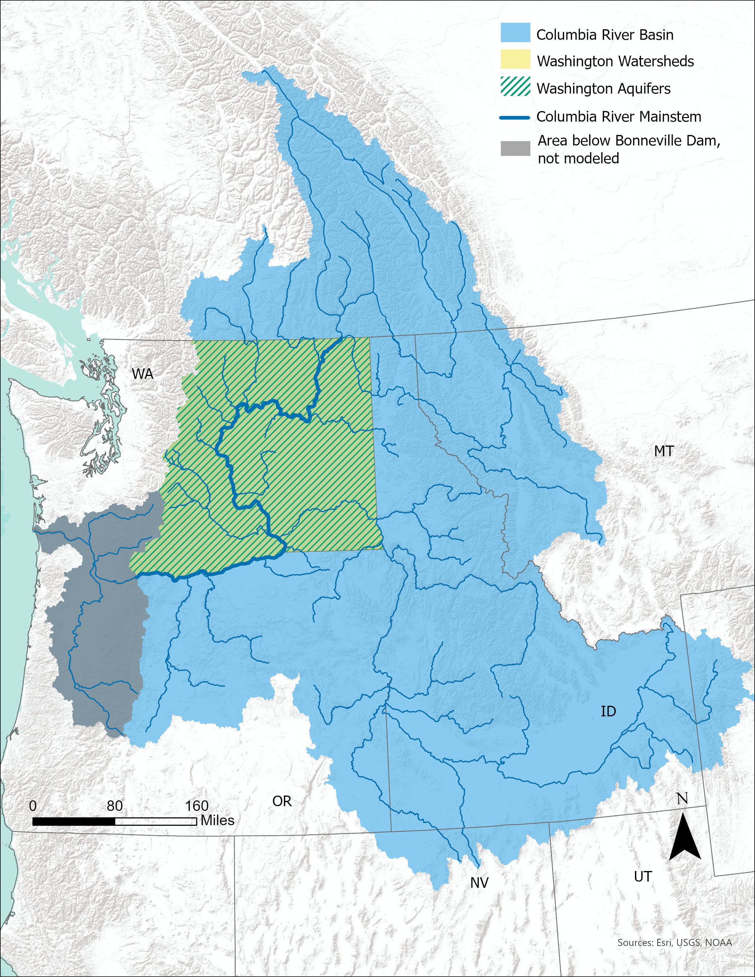
It’s no secret that winter 2022/2023 was exceptionally snowy, and - quite literally - record-breaking in the western US. Throughout the winter we read news headlines that quickly progressed from “epic snow year” to “potentially record-shattering” and finally to “largest-ever snowpack”. These bold headlines in the media were validated by the US National Resource Conservation Service’s (NRCS) SNOTEL network, which revealed that  snow water equivalent (SWE) values sky-rocketed well above normal in nearly all western US basins. This positive outlook continues through late spring for southern states in the west — the snapshot from late May shows an above-normal snowpack for many basins in Oregon, Nevada, Utah, and Colorado.

Western US Snow Water Equivalent values are above normal for southern states in the West and below normal for northern states.

Digging Out From a Big Hole

This prodigious snowpack couldn’t have come at a more desperate time. Last summer, drought conditions across the western US reached all-time severity with numerous regions reaching D3 (Extreme) and D4 (Exceptional) drought stages. Many states experienced major losses to crops and pastures, and numerous water shortages and restrictions were put into place. With winter 2023 in the rear view mirror and summer just ahead, it’s difficult to imagine that, in just a few months’ time, much of the western US will return to a dry, drought-stricken landscape, but unfortunately, that’s the reality we face. Even a record-breaking snowpack cannot make up for numerous years of back-to-back drought conditions.

The tension created between the ongoing drought and this year’s snowfall demonstrates the challenges of western water management and how one good snow year can create an illusion of water security.

The Endless Winter Fights Back

While this extraordinary winter won’t completely erase the megadrought, the short-term drought outlook has improved significantly.  A drought summary posted by the National Drought Mitigation Center on May 23, 2023 shows a dramatic improvement for most of the western US over the last year, with most area’s drought classifications downgraded by one or more classes.

Changes in drought classifications across the US.

But as welcome as this improvement is, it’s going to take more than one good snow year to dig ourselves out from the deep hole we are in. Much of the US is still categorized as either D0 (Abnormally Dry) or D1 (Moderate Drought) with some select regions continuing to worsen, even after this winter. The following two images show recorded drought conditions almost exactly one year apart.

Drought conditions comparing May 2022 to May 2023.

The New and Fragile Normal for Water Supply

Water managers rely on forecasts to predict the volume of available water supply for the upcoming spring and summer months. Generally, a bigger snow year means a better forecast and more water availability. But total snowfall is only one piece of the water supply puzzle, and other factors, mainly brought about by a more volatile climate and our changing society, can create additional challenges.

Some of the challenges today’s water managers face include:

  • Higher overall demand for water and more consumptive uses brought about by population growth.

  • Difficulty with the management of the timing of runoff (earlier melting) – warmer-than-average spring temps and more dust-on-snow events (which expedites melting) are causing severe flooding and other adverse impacts. Overall, severe runoff is less beneficial for water supplies as it overwhelms water storage infrastructure and is difficult to capture (something stormwater experts are grappling with as they look to design infrastructure for a changing climate).  

  • Thirsty soils – already dry soils take up less water than saturated soils, leading to more runoff and less water supply capture.

  • Previously depleted groundwater resources and surface water reservoirs – “digging out of a hole”.

Water Managers Look to Variety of Strategies to Harness Retimed and Excess Water

These challenges, combined with a volatile climate, mean that one wet winter won’t be enough, and leave water managers facing a difficult task.

Fortunately, solutions such as water banking, watershed planning, and aquifer storage and recovery (ASR), can be deployed to combat these challenges and capitalize on the periods of excess runoff water. And thanks to the unprecedented volume of available funding opportunities for water sustainability, conservation, and efficiency projects, these solutions are becoming more widespread and are proving to have effective implementation.

Aspect is heavily involved in water banking, watershed planning, and ASR, helping western clients with short-term and long-term water supply projects. Additional detail about Aspect’s past and current involvement with these strategies can be found below:

2040 Temperature Check on One of North America’s Biggest Watersheds

More water earlier and less snow – the Columbia River Basin’s water health was recently forecast into 2040 as the result of a two-year study across the Washington State Department of Ecology, Washington State University, University of Utah, State of Washington Water Research Center, and Aspect Consulting in the 2021 Long-Term Water Supply & Demand Forecast.

Photo Credit: Robyn Pepin, Aspect Consulting. Columbia River near Entiat

This mammoth water evaluation project – done every five years since 2006 – looks across the Columbia River Basin, which includes 34 eastern Washington watersheds. Hydrological modeling, economic modeling, regulatory context, remote sensing, surface water and groundwater monitoring and more all are studied to predict the future of water for agriculture, population growth, and instream flow health under a changing climate in this critical basin.

Forecast Insights for the 4th Largest Watershed in North America

Image Source: 2021 Columbia River Basin Long-term Water Supply and Demand Forecast

The Columbia River Basin is the 4th largest watershed in North America, running down from headwaters in Canada and mainly into four states – Washington, Oregon, Idaho, and Montana. Some notable details and insights from the recent forecast include:

  • Wet months getting 15% more water and dry months getting 28% less water

  • Earlier planting dates and more heat stress during the hot months

  • 17% higher population growth across Washington state leading to increases in demand for residential water and hydroelectric power

  • Trends in groundwater levels across the last 20 years were predominantly declining across the basin. The steepest declining trends correspond with the most heavily pumped layers and areas such as the Grand Ronde aquifer in the Odessa Sub Area and the Wanapum aquifer in parts of the Yakima Basin and Horse Heaven Hills.

Expected changes that will influence future water supplies and demands. These expected trends inform the scenarios explored in the 2021 Forecast.

Graphic Source: 2021 Columbia River Basin Long-term Water Supply and Demand Forecast

A 2040 Water Crystal Ball: Water Retiming Means More Water Earlier

Among the many takeaways in this report is the impact of climate change on water cycles. Chief among those is the prediction that peak surface flows – that feed the historically typical April – October agricultural season – will begin earlier, thus leaving less water available later in the summer when demand for that water is higher. Snowpack – the Pacific Northwest’s natural water reservoirs – will likely melt earlier because of warmer temperatures.

This ripple effect will influence agriculture starting earlier in the growing lifecycle; instream flow challenges with higher temps for fish habitat; and populations in arid regions will likely be incrementally more dependent on groundwater to serve future water supply. Declining groundwater trends mean that alternative water supplies may not be available in some areas so additional solutions are needed.

Time (in years) until the average available saturated thickness has declined by 25% in at least one aquifer layer in each groundwater subarea.

Image Source: 2021 Columbia River Basin Long-term Water Supply and Demand Forecast

State-of-the-Science Research

Aspect teamed with the project team and the scope of the science and monitoring over the last two years is impressive. A team of scientists and engineers looked at remote sensing and telemetry data across eastern Washington; climate change forecasts; population growth projections; well logs; and water rights. Some of the months-long study details of that include:

  • Integrated hydrological, river operations, crop production, and municipal, domestic and industrial water demand modeling in 34 watersheds under 34 potential climate change scenarios

  • Groundwater level trend analysis on 670+ wells

  • Automated well log review of over 4,000+ well logs

  • Manual well log review of 300+ well logs

Learn more also at WA Ecology’s project StoryMap here.

How 300 SNOTEL Sites Forecast the Pacific Northwest’s Annual Water Future – Part 1

Nearly 300 climate monitoring stations (SNOTEL sites) scattered across Washington state hold the data to our largest and most valuable reservoir: The Winter Snowpack. As of early February 2022, our water year began typically but has trended warm. We did get plenty of snow in the Cascades and Olympics – the critical mountain ranges that store our state’s water future. Read on for Part 1 of our two-part series, where we’ll distill the SNOTEL data, and then come back in the spring to see how the 2022 snowpack fed water resources in the Pacific Northwest.

A look at Mount Shuksan during some backcountry ski touring. This area around Mount Baker receives some of the highest snowfall in the Pacific Northwest. In the spring, the melting snowpack feeds major rivers in Northwest Washington, across Whatcom and Skagit County.

Snowpack is the Key to Fish, Flows, and Agriculture

Snowpack is vital to Washington’s water supply; we all depend on this resource as it piles in our mountains in the winter and melts in the spring to replenish streams and groundwater. Its impact is counted on by:

  • Farmers – To grow crops with irrigation water from streams fed by snowpack

  • Cities and Counties – To supply homes from groundwater replenished by snowpack

  • Industries – To generate hydroelectric power from rivers fed by snowpack

  • Salmon – To feed cool and clear water to critical fish habitat

Winters of below-normal snowpack add strain to the teetering balance of water supply and demand and challenge water managers throughout the state. Fortunately, this strain does not come as a blindside because of the SNOTEL network.

Basin-filled map showing percent of median across Washington State on February 1, 2022.

SNOTEL Surveys Washington’s Water Future

A growing network of nearly 300 climate stations (SNOTEL sites, short for SNOwpack TELemetry) monitor our changing snowpack reservoir in real-time, revealing whether the snowpack is below- or above-normal. This is managed by the U.S. Department of Agriculture, who provide this free publically available data. This allows regulatory agencies to make early decisions to manage the level of risk in receiving more or less water than planned for in spring, when the ‘reservoir’ stored in the snow transforms into streamflow that replenishes rivers and groundwater basins throughout the state.

Snow Water Equivalent – Not Just for Skiers and Boarders

Many people may associate snowpack in terms of snow depth. However, in the context of water supply to fish/flows/communities, of greater importance is the snow water equivalent (SWE). If you take a volume of snow and melt it, the volume of water left is SWE. SWE is a better measure of how much water is available in the spring meltout. The water content of falling snow can be highly variable: five feet of dry powdery snow is not equivalent to five feet of wet heavy snow.

How’s it looking? A Summary of Washington February 2022 Snowpack

Water year 2022 (‘Water Year’ always starts on October 1 annually, unlike the calendar year) began typical and uneventful; however, by mid-November, a battering of atmospheric rivers delivered warm and wet conditions to the state. While rainfall records were shattered (wettest fall in recorded Seattle history), warm temperatures quickly erased any progress of previous snowpack development and the 2022 snowpack (the black line) initially fell under the normal line (see green line below). As we crossed into December, the snowpack regained momentum, crossing above the normal line.  By January and into February, the state’s snowpack plateaued, ending right at the normal values, to date.  

Snow Water Equivalent (SWE) in Pacific Northwest Region. The black line shows 2022 SWE trends to date. The green line shows normal “median” snowpack blue and red lines show the max and min (% median).

As of early February 2022, the Pacific Northwest snowpack is 102 percent of normal. In Washington, the highest reading of SNOTEL data in the State were at 109 percent of normal in the Lower Columbia Basin. The Lower Yakima has the lowest reading at 83 percent of normal.

Using SNOTEL to See Our Water Reservoir Forecast

As the SNOTEL data illuminates, our snowpack story is fluid. This year, so far, is trending around normal. However, the value of having 300 monitoring stations is mountains of data to measure our state’s water health. This gets more and more important as the weather turns warmer and farmers, fish, and communities seek out the meltout from the reservoirs in the mountains. Check back in April 2022 for Part 2 of our SNOTEL water summary where we’ll look back at how our 2022 snowpack reservoir turned out.

The Nooksack Adjudication: A Pivotal Washington State Water Story

In Fall 2020, after decades of unresolved conflict, Washington State made a decision to initiate a “general adjudication” on a key Northwest Washington watershed – the Nooksack basin in Whatcom and Skagit Counties. This means that thousands of water right users will be formally evaluated. What does this mean? In a word certainty. Certainty for the State of Washington, Tribal governments, and the water users themselves. Why is this happening now? It’s the most common water story in the West – there’s just not enough water to go around.

The Nooksack watershed is one of two areas (WRIA 58, including Lake Roosevelt, was the other one) recommended for adjudication.

The Nooksack watershed is one of two areas (WRIA 58, including Lake Roosevelt, was the other one) recommended for adjudication.

Adjudication – What is it?

An adjudication is a binding court Decree by the state whose end result is a comprehensive inventory of valid water rights. Put in simple terms it means that an Adjudication Court, with support from the Washington State Department of Ecology (Ecology), will methodically review all water uses in the watershed and confirm each water right has ‘valid’ water uses.

Why Now: What’s happening in Northwest Washington?

More rural development. Unquantified Tribal water rights. More water needs for agriculture in a growing part of the Pacific Northwest. Keeping water in the stream for fish. These competing demands often emerge as ‘whose water is this?’ battles in water rights. In Skagit and Whatcom counties, the adjudication is looking to bring certainty; however, there’s a lot of differing opinions on how to get there.

The Second Biggest Adjudication in Washington State History

Washington State is a ‘first in time first in right’ state for water law. Another way of saying it is if you were there first in using water, you are at the head of the line. That line can extend over a century in Washington state, and over generations if the water right passes on via property transfers. The Nooksack adjudication is potentially very big in scale.

The biggest one was in Yakima, and that took over 40 years to resolve including six Supreme Court cases. The schedule for the Nooksack will hopefully be more compressed, and Ecology plans to try out several time-saving shortcuts to make the process more streamlined.

Here to help as the State’s Preeminent Water Rights Firm

Aspect has consulted on literally thousands of water rights in Washington state in the last 10 years. We have also been involved in Nooksack water resources for more than a decade, including helping to lead the most recent watershed planning in 2021. We are looking forward to working with Nooksack water users.

Learn more here: www.nooksackadjudication.com

Celebrating Key Watershed Plans in Spokane and Okanogan Basins

January 2021 launched great news for watersheds across Washington state – but first, let’s recap.

The $300 Million Watershed Law

In 2018, following water rights uncertainty that held up a $4 Billion budget in Washington State, the state passed the $300 Million Streamflow Restoration Act. The prime target was unlocking more water in a way that benefits habitat, communities, and agriculture and allows thoughtful development plans to proceed. Fast forward to 2021 and counties and basins across the state are seeing the outcomes of that law – most directly 6 out of 15 basins have updated watershed plans to date.

Status of Streamflow Restoration Grants and Planning Process
Source: Washington State Department of Ecology

Key Takeaways of Streamflow Restoration Act Results (So Far)

  1. Permit-exempt well impacts on instream flows and water right holders will be completely offset for the next 20 years.

  2. Local watershed partners have once again demonstrated they can collaborate on local solutions to water supply challenges.

  3. The plan adoption paves the way for shovel-ready projects to be implemented to benefit streamflow.

In three of those basins – Little Spokane (WRIA 55), Okanogan (WRIA 49), and Chehalis (WRIA 22 and 23) – there has been real progress on planning for the future water needs of the region. Aspect has worked for years on two of these (Little Spokane and Okanogan) and is excited to see the positive outcomes so far.

Little Spokane Watershed (WRIA 55) Plan Update

Headwaters of the Little Spokane River, near Newport, WA

Aspect has worked with Spokane County over the last several years to support watershed planning and management, including the development of watershed restoration projects. On January 28, 2021, Ecology adopted the updated Little Spokane Watershed Management Plan. This will mean:

  • Spokane County is in the process of completely offsetting permit-exempt well impacts and developing streamflow improvement projects totaling 4,085 acre-feet, including:

    • Purchasing water rights as mitigation

    • Building a Managed Aquifer Recharge project

    • Studying approaches for increasing storage in Eloika Lake to improve summer streamflows, combined with wetland and habitat enhancement

Okanogan Watershed (WRIA 49) Plan Update

Aspect has worked for years with Okanogan entities like Oroville-Tonasket Irrigation District (OTID) and others to lead up to this watershed planning update. This will mean:

  • The lead Okanogan watershed planning group -- WRIA 49 Planning Unit -- developed a two-tier list of projects to be adaptively managed to provide both consumptive use water offset and achieve Net Ecological Benefit in a manner consistent with the strong agricultural values of the community.

  • Two projects – Antoine Valley Ranch and Methow Beaver Project’s Restoring Streamflow after Wildfire in Okanogan and Methow River Subbasins – have been funded by Ecology and will be the first projects implemented following the adoption of the plan.