Attracting Talent – Simple Steps, Great Results

Lindsay Pearsall - Director of Human Resources

Earth science and engineering firms are in a buyer’s market in 2019. Anyone in a leadership position in the Architectural/ Engineering/ Construction industry knows the mantra of “Always Be Recruiting.” At Aspect, we are no different. Our success (and our clients’) hinges on our ability to find and retain the most talented consultants in our industry. It’s essential, then, that our Human Resources department takes a very thoughtful approach to finding and hiring this top-tier talent.

Recently, at RecruitMAX 2019 – one of the A/E/C industry’s top professional industry conferences—Aspect’s HR Director Lindsay Pearsall shared a segment of her approach with a presentation “How to Build a REAL Candidate Pipeline with Phone Interviews and Informational Interviews.”

Some takeaways of Lindsay’s presentation are:

  • Why treating your candidate like a client should be your #1 priority

  • Conducting informational interviews to go beyond your current hiring needs

  • Simple solutions, like how and when to follow up with individuals, to maintain relationships

Lindsay’s presentation stressed that hiring managers need to remember how difficult it is to be a candidate. By flipping the script and treating candidates like a client, we are able to humanize the experience. Whether someone is hired or not, they should have an expectation of a positive experience and feel valued as a professional and as a human.

See current job openings for Aspect here: https://www.aspectconsulting.com/careers

Perspectives on Water Resources Engineering: Taylor Dayton in the Zweig Newsletter

Taylor Dayton, Project Engineer

Aspect’s Taylor Dayton was recently interviewed in the Zweig Newsletter on a range of topics — from transitioning from working at NASA as a biochemist to an engineer, to learning water rights legends, project management lessons learned, and navigating an early career in the water resources field.

Read about it here: Apple orchards and water rights

Reducing Washington State Drought Impacts in the Okanogan River Basin

In both the northern reaches, high desert region, and even the Olympic Peninsula—literally one of the wettest places in the lower 48 states historically—summer 2019 is a serious drought year in Washington State. Earlier this spring, the governor declared a drought emergency, which was able to unlock emergency relief options and funding for 27 watersheds across the entire state. In the Methow, Okanogan, and upper Yakima River watersheds, it’s particularly bad. Based on current forecasting, the Okanogan is expected to be at 58 percent of normal, and curtailment notification letters have already been sent to local water users. However, this drastic forecast has prompted forward thinking. 

In partnership with the Washington State Department of Ecology (Ecology), the Oroville-Tonasket Irrigation District (OTID) has developed a “water bank” in the Okanogan River basin to help regional water users impacted by the drought. The water bank will be used to support instream flows and to assist “junior” water users during periods of curtailment. OTID is seeding the bank with two of its senior water rights. In 2018, Ecology, with assistance from Aspect, certified these water rights through the state’s Certified Water Right Examiner process. 

Ecology is working to complete the required permitting to place the water rights in the state’s Trust Water Right Program (TWRP) to create the water bank (read more about water banks on Ecology’s website). This water bank will be seeded with about 7,500 acre feet of water, which will be made available for drought relief. From this bank, eligible water users can “withdraw” water for both irrigation and municipal or domestic uses.

 More information can be found at the following website:

https://www.aspectconsulting.com/otidwaterbank

Waiting for Water - the Columbia Basin Project

Aspect works routinely with clients suffering from declining groundwater supplies. From conservation and planning projects to aquifer storage and recovery (ASR) projects, Aspect is at the forefront of this issue. ASR projects in Othello and White Salmon are underway now that will assist in long-term certainty for public water supplies in the future. In agriculture, we are partnering with Washington State University to forecast how declining water supplies will affect commercial crop reliability and assessing the conservation, storage, and water marketing tools that exist both locally and regionally to assist them. One of the largest declining groundwater areas in the state is in the Columbia Basin.

This video “Waiting for Water – The Columbia Basin Project” produced by the Columbia Basin Development League is a great introduction into the complexities of these issues for farmers in Washington. Aspect staff assisted in the permitting and environmental review for this project.

Air Quality Rule Change Means Lower Hurdle for Washington State Landfill Owners

The Washington State Department of Ecology is revising the air quality thresholds for toxic air pollutants (TAPs; WAC 173-460), based on best available science. These proposed changes have some significant effects for landfill owners looking to keep air quality good, protective of human health and the environment, and doing so cost effectively. The key proposed changes are:

The last flare this landfill in Port Angeles will ever need. When the gas is no longer combustible, reliable treatment will be provided by biofilter technology – made easier by recent updates in air quality criteria.

  • Two of the most conservative constituents commonly found in landfill gas, benzene and vinyl chloride, will have higher thresholds (by factors of 3.7 and 8.9, respectively).

  • The threshold for hydrogen sulfide – a common driver for odor control in landfill gas – did not change. However, biofilter technology is showing promise as an economic and reliable method for polishing treatment.

  • The threshold for trichloroethene went down by a factor of 0.4. This constituent has also been commonly found in landfill gas, and the new threshold may or may not change our clients’ treatment obligations.

What this means for landfill owners is that air quality compliance should be easier to demonstrate. This means:

  • Downscaling treatment at older landfills can focus on odor control instead of destruction efficiency for volatile organic compounds (VOCs) as TAPs.

  • The costs associated with flaring landfill gas can be re-directed to biofilter technology for polishing treatment for odor control.

  • The schedule for ending or minimizing post-closure obligations associated with landfill gas treatment can be accelerated.

Next Steps

This rule-making process is on-going, and details of the process are provided at Ecology’s website: https://ecology.wa.gov/460rulemaking.

A hearing on the re-calculated air quality thresholds is planned for July 16, 2019, and comments are due be July 23, 2019.

Barring delays, the new rule on air quality thresholds becomes effective in late October 2019.

For more information on what the implication of these changes for landfill owners and managers, contact Associate Engineer Peter Bannister at (206) 780-7728 and pbannister@aspectconsulting.com.

A Peek Inside Washington State's Draft Industrial Stormwater General Permit

Stormwater discharges from over 1,200 industrial facilities are covered under Washington’s Industrial Stormwater General Permit (ISGP). The goal of the ISGP is to reduce the discharge of pollutants by improving management of stormwater at industrial sites. It originates from a combination of federal (the Clean Water Act) and Washington state (Water Pollution Control Act) law. Under the ISGP, permittees are required to implement Best Management Practices to reduce stormwater pollution, monitor their stormwater discharges, compare the results with benchmark values, and implement an escalating series of corrective actions depending on the number of times the benchmarks are exceeded. The current permit has brought compliance challenges, including expensive stormwater treatment systems and citizen law suits, to many permittees.

On May 1, 2019, the Washington State Department of Ecology (Ecology) published a draft of the next ISGP for public comment. Owen Reese, PE, Aspect’s stormwater practice lead, offers this synopsis:

What Won’t Change

Many of the key permit provisions will not change. The five core water quality benchmarks—turbidity, pH, oil sheen, copper and zinc—remain the same, and the requirements and deadlines for implementing corrective actions if those benchmarks are exceeded remain unchanged.

Proposed Changes

Increasing Focus on Infiltration to Groundwater – The most significant proposed changes relate to discharges to groundwater. Ecology is proposing changes to groundwater-related provisions that leave the impression that they intend to increasingly regulate infiltration of stormwater under the ISGP. This sets Ecology on a divergent course from the US Environmental Protection Agency (EPA), who recently issued an interpretative statement that discharges to groundwater are categorically excluded from the permitting requirements of the Clean Water Act. The interpretative statement does not apply to Washington and other states in the 4th and 9th Districts while Hawai’i Wildlife Fund v. County of Maui is pending before the Supreme Court. 

Ecology has also struck language from the permit in several locations, including key groundwater-related provisions, without identifying it as a change—which could be problematic for reviewers.

Adding Two New Industries – Ecology proposes to add two new industries to ISGP coverage: marine construction and certain heavy equipment rentals. Neither of these industries are currently required to have NPDES coverage for stormwater discharges under the Clean Water Act. What activities qualify as “marine construction” can also be challenging to define as it does not fall within easily definable Standard Industrial Classification (SIC) or North American Industry Classification System (NAISC) code, and Ecology confounds this issue by not including the definition of marine construction in the draft ISGP.

Identifying Industries by NAICS Codes – Ecology proposes to identify industries that require ISGP coverage by NAICS code, instead of SIC code. The Clean Water Act remains based on SIC codes, and there is a not a one-to-one relationship between the two codes. As a result, Ecology’s translation of SIC codes to NAICS appears to have included, perhaps inadvertently, several business sectors that previously did not require permit coverage, such as:

  • Miniwarehouses and Self-Storage Units (NAICS 531130)

  • Scenic and Site Seeing Transportation (NAICS 487990)

  • Commercial Air and Rail Equipment Rental (NAICS 532411)

Puget Sound Sediment Cleanup Sites – Ecology has re-upped the requirements that permittees discharging to a Puget Sound Sediment Cleanup site (such as the Duwamish, Elliott Bay, Commencement Bay, Port Gardner Bay, or Bellingham Bay) will need to sample stormwater sediments and clean their pipes at least once in the next 5-year permit cycle. It was not clear in the prior permit that these would be recurring obligations.

Annual Sampling to Confirm Consistent Attainment – Under the draft permit language, facilities that have achieved consistent attainment by meeting water quality benchmarks would be required to collect one sample per year (in the fourth quarter). Any exceedance of a benchmark would bump the facility out of consistent attainment and require resuming quarterly sampling.

Sampling First Fall Storm Earlier – Ecology proposes to shift the requirement to sample the first flush a month earlier, to beginning September 1 of each year. We’ll likely see more third quarter benchmark exceedances as a result, as there are fewer summer storms to sample to average with the first flush.

What the Proposed Changes Could Mean

Although ostensibly aimed at providing clarity, the revisions incorporated into draft ISGP actually increase the opportunity for confusion. If the draft ISGP language is implemented, we may see more citizen suits, particularly related to the use of NAICS codes and stormwater discharges to groundwater. Ecology could remedy some of these concerns by clearly identifying which provisions of the ISGP are based in federal law, and which originate at the state level.

Comments on the draft permit are due on June 29 and can be submitted online at: http://ws.ecology.commentinput.com/?id=k3Zx2. Ecology is also hosting three more public hearings where comments can be given in person:  

Contact Owen Reese at 206-838-5844 or oreese@aspectconsulting.com with any questions on the proposed changes and implications.

Aspect personnel collecting a sediment sample at an industrial site.

Dave Cook Discusses Consent Decrees, Cleanup and Ecology’s Healthy Housing Program for Contaminated Sites at the WA Brownfields Conference on May 30, 2019

On May 30, Aspect’s Dave Cook will co-present on affordable housing development from the environmental consulting perspective at the Washington State Brownfields Conference in Spokane.

Brownfield properties represent opportunity. Dave will talk about innovative ways to turn blighted property into affordable/work force housing. Aspect’s first-of-its-kind work on the Mt Baker Housing Association’s Gateway project in the Mt Baker/Rainier Valley neighborhood in Seattle has become an example of what is possible. Mt Baker Housing Association (MBHA), as a non-profit, took on a significantly contaminated site to redevelop as affordable housing where the cost of the cleanup is more than the value of the five properties combined. Dave will join Scott O’Dowd of Ecology, Conor Hansen of MBHA and Mike Dunning of Perkins Coie to describe how these properties were purchased, investigated, liability managed, and the cleanup financed—all keys that made this pioneering project successful and sparking the State’s new Healthy Housing program .

Contact Dave (206.838.5837 and dcook@aspectconsulting.com), or learn more about prospective purchaser consent decrees, funding, and redeveloping contaminated land for affordable housing at https://www.aspectconsulting.com/affordablehousing


Aspect Talks Reclaimed Water, ASR, and Walla Walla Basin at 2019 AWWA

Andrew Austreng, Jon Turk, and John Warinner will be presenting Thursday and Friday May 2 and 3rd at the American Water Works Association (AWWA) ‘River Runs Through It’ 2019 Section Conference in Vancouver, WA. Andrew will present on the Othello, WA Aquifer Storage and Recovery project; Jon Turn will showcase groundwater recharge strategies for a unique project involving reclaimed water in Kitsap County; and John Warinner will discuss challenges and opportunities of managing groundwater across two state lines in the Walla Walla subbasin.

The annual AWWA conference is one of the largest conferences for water professionals in the Pacific Northwest.

New GIS Tool Helps Remove Barriers to Salmon Habitat Connectivity

Clean, cold water. Lush riparian vegetation. Gravels for spawning. These are some of the elements that create healthy habitat for salmon. The Upper Columbia region has some of the best in the Pacific Northwest. Unfortunately, not all of this habitat is within the salmon’s reach. Removing barriers such as culverts and dams is a top priority for salmon recovery goals, but there are thousands of barriers, limited resources to remove them, and a diverse group of stakeholders with issues to address. What everyone wants to know first is: how do we decide WHICH barriers to remove?

Instream barriers such as culverts like this can limit fish passage to available habitat.

Enter a New Tool for Fish Habitat Decision Making

In partnership with the Cascade Columbia Fisheries Enhancement Group, the Upper Columbia Salmon Recovery Board, the Upper Columbia Regional Technical Team (RTT), and a technical steering committee, Aspect created a GIS-based decision support tool that summarizes the overall quality of ecological conditions surrounding each instream barrier within the Wenatchee Basin. This custom spatial model provides insight into critical questions regarding barrier-removal priority:

  • Is there habitat available upstream from the barrier that salmon currently cannot access?

  • Is that available habitat of sufficient quality for salmon?

  • Is there known fish usage near the barrier already?

  • Are there barriers downstream blocking fish access?

This prioritization tool provides salmon-recovery stakeholders with a common approach to answer these questions. The variables under consideration at a barrier—upstream habitat quality, local stream temperature, connectivity to other barriers, etc.—each receive a score. Those scores are then added up to a total priority tier ranking for that barrier. By assessing each barrier through this scoring process, we’ve created an actionable apples-to-apples comparison of habitat benefits associated with barrier removal.

A preview of barrier removal ranking priority data.

A Tier 1 ranking indicates the top priority for removal, indicating more biological benefit gained from a barrier’s removal. Tier 4 ranking is the lowest priority ranking, indicating little biological benefit gained from a barrier’s removal. UCSRB and the RTT use these categories to guide decisions on proposed project funding. The rankings are updated as available data sources improve.  Preview the results HERE. This tool will allow stakeholders to align and coordinate their barrier removal work towards the larger common goal of salmon-habitat connectivity within the Upper Columbia and throughout the state.

If interested in adapting this tool for your project and/or basin(s), contact Robyn Pepin for more information.

ETA (6/3/2019): Robyn Pepin and Taylor Rulien’s poster for this GIS tool won best analytical data presentation at 2019’s WAURISA Conference. Check it out here.

MTCA Turns 30

Happy 30th Birthday to the Model Toxics Control Act (MTCA)­—Washington’s citizen-led law put in place to help cleanup over 7,000 sites statewide. Those thousands of cleaned up sites have led to a cleaner environment, better human health, and thriving communities. The interpretation or implementation of it has had some bumps and difficulties, but on balance MTCA has been very beneficial to the common good and, as the video discusses, an example nationally of a successful cleanup process. As a firm that helps clients interpret and cleanup sites, Aspect is proud to be a part of its effect on all of us.

Checkout Ecology’s short video for the history and highlights of this important and innovative law.

Learn about the history of Washington's citizen-led environmental cleanup law - the Model Toxics Control Act. This innovative law powers our work to investigate, clean up, and prevent hazardous waste.

Carla Brock Chairs WA’s Geologist Licensing Board

Associate Geologist Carla Brock was recently appointed as Chair of the Washington State Geologist Licensing Board by her fellow board members. The board is comprised of six licensed geologists and one public member and is responsible for licensing geologists; updating the rules and regulations governing the practice of geology in the state of Washington; and investigating violations of the regulations. Carla is starting her second year of a four-term appointment to the board.

Washington State is a member of the National Association of the State Boards of Geology (ASBOG), which develops standardized written examinations for administration by the 32 member states and Puerto Rico, assessing qualifications of applicants seeking licensure as professional geologists. In addition to her duties on the state board, Carla participates as a Subject Matter Expert (SME) on ASBOG’s Council of Examiners (COE). The COE is comprised of SMEs from across the country and convenes twice a year, immediately following administration of the tests, for examination development and validation workshops. The COE spends two days reviewing test questions and answers to maximize the fairness and quality of the examinations as measures of competency. The COE is not all work, each meeting includes lunchtime presentations by local experts on interesting and relevant topics and a third day in which local experts lead a geologic field trip.

Carla just returned from the spring COE, which was held in Nashua, New Hampshire and is proud to support ASBOG but also enjoys the opportunity to connect with colleagues from across the country and to learn about local geology.

Geologists love a good roadcut! A quartz syenite ring dike intrudes the pre-Mesozoic tonalite with mylonitization at the contact.

Geologists love a good roadcut! A quarts syenite ring dike intrudes pre-Mesozoic tonalite.

Geologists ogling an outcrop in central New Hampshire.

Geologists stomping through the snow in central New Hampshire in search of an outcrop.

Talking Field Data Collection at 2019 OCEAN Connect Conference on April 11

Over the past decade or two, technological advancements have presented opportunities to streamline field data collection. However, migrating field staff to a paperless workflow requires more than choosing the right software and hardware.

On April 11, Aspect’s John Warinner and Robyn Pepin will cover this topic and give tips on how to effectively convert field data collection from paper to digital process at the 2018 Oregon Conservation Education and Assistance Network (OCEAN) Connect Conference in Sunriver, Oregon.

Key areas of the presentation will include:

  • Overview of commercial off-the-shelf software and reporting systems

  • Case studies and lessons learned by Aspect’s field and data teams

  • Successful talking points to convince decision makers

See good field techniques and analysis put into practice, with some mountain biking thrown in for good measure here:

It's IPAD Mini vs. Trimble GPS in a mapmaking showdown on the sunny trails of the Chelan-Douglas Land Trust in the Wenatchee Valley.

And read more about our experience with how one suite of field data technology has improved our workflow.


Taylor Dayton Presenting on Water Rights as Mortgage Assets to NAPMW - April 12

Taylor Dayton, Water Resources Engineer

Aspect Water Resources Engineer Taylor Dayton, EIT, will present at the National Association of Professional Mortgage Women (NAPMW) LPO Seminar in Lake Chelan on Friday, April 12, 2019. The presentation will explore water rights as assets in the mortgage industry - how water rights are created, moved, lost, and valued. Taylor will also speak to the recent Hirst decision and “fix” and how it affects eastern Washington water rights and development.

The State’s Longest-Running Water Rights Adjudication is Coming to an End

In 1977, James J. Acquavella’s name was listed first on the summons when Ecology filed a petition for an adjudication to determine the legality of all claims for surface water in the Yakima River Basin – birthing the Ecology v. James Acquvella, et al water rights case. Forty-two years and 2,500 claimants and interested parties later, it is coming to a close. Some takeaways for this milestone moment in Washington state water management are:

  • Starting in 1977, the Department of Ecology v. Acquavella adjudication is the longest-running general adjudication in state history, determining the validity and establishing priority of surface water claims in the Yakima Basin.

  • With the issuance of the Final Decree by Yakima County Superior Court, water right holders in the Yakima Basin will finally have certainty over the authorized quantities and purposes and places of use of their water right claims.

  • Adjudicated water right certificates will be issued by Ecology for all claims determined by the Court to be valid; water right holders will no longer need to get approval of the Court to complete a change or transfer a water right, but instead file applications with Ecology like everywhere else in the State.

  • During the adjudication, stakeholders in the Yakima Basin continued to lead the state in providing innovative approaches to water resource management challenges, including early adoption of water banking and mitigation markets to ease permitting of new water rights, and development and implementation of the Yakima Basin Integrated Plan.

Aspect has worked on a variety of Aquavella claims over the decades – including hundreds of due diligence water right evaluations; helping buyers/sellers move and change these rights; and developing water banks through the State’s Trust Water Right Program to support efficient transfer of existing rights and permitting of new, mitigated water rights.

Read the fascinating tale of water management in the Yakima River Basin and the implications of this ruling in this great Department of Ecology blog post.

See what else Aspect’s Water Resources practice has been up to.

Recognizing World Water Day

Water is a scarce resource for many worldwide. The United Nations has designated today, March 22nd, as World Water Day to raise awareness of the billions of people—about 3 in 10—living without safe water. As earth science professionals, this message strikes a chord with Aspect staff who spend many of our work hours towards helping clients find, produce, and manage water. Supporting NGO goals – like the UN’s “water for all by 2030” – is important to us. Whether it’s organizations like UN or Engineers Without Borders USA, please join us in learning more about these worthy causes.

https://www.worldwaterday.org/

International Women’s Day at Aspect

Aspect celebrated International Women’s Day with a gathering and conversation sparked by a video produced by Lean In as part of their 50 Ways to Fight Bias program. The video defined the common biases women experience at work and beyond:

  • Performance (underestimating women’s experience and performance)

  • Attribution (women get less credit for success, more blame for failure)

  • Likability (been agreeable can be seen as less competent, while being assertive can make one less likeable)

  • Maternal (choosing to become a parent can be seen has having less commitment to career)

  • Affinity (people tend to gravitate towards people who are similar in appearance and background; when only white men hold positions of power, this has a negative effect on women and people of color)

  • Compounded discrimination + Intersectionality (the compounding affect of bias due to gender, race, sexual orientation, disability, and other attributes)

Thirty-three percent of Aspect’s staff of 107 are women, including 15 percent of Aspect’s technical/engineering staff, which is slightly higher than the statewide percentages for female engineers –11 percent in Oregon and 12 percent in Washington. In 2018, 21 percent of our technical hires were women.

The theme for International Women’s Day 2019 was Balance for Better, encouraging action towards creating a more gender-balanced world. Some of our staff modeled the “Balance for Better” pose to show our commitment to finding that balance.

Breeyn Greer, EIT, Staff Environmental Engineer (left) and Amelia Oates, GIT – Staff Geologist (right) at Aspect’s Field Annex in Seattle

Amy Tice, LG, Project Geologist, and family

Carla Brock, LHG, Associate Geologist

“Balancing bike racing with my career is always a challenge, and requires that I am super organized and efficient with my time, but somehow I figure out how to make it work.” – Delia Massey, EIT, Project Engineer

Jennifer Koogler, Technical Editor

“Being the only woman in the Portland office—and in all of Aspect’s Oregon offices—doesn’t hinder my ability to stay focused and produce quality work. The attitude Aspect has towards women in the workplace is really motivating and makes me proud to be a part of the company. We have incredibly intelligent and strong women who shine brightly here, and as a young staff person, I am thankful to have them as my mentors.” –Jasmin Jamal, EIT, Staff Engineer, and Cooper on Mt. Tabor

Jessica Smith, LG, Associate Geologist

Meghan O’Brien, CWRE, Project Scientist

(Left to right) David Unruh (Staff Scientist); Chip Barnett, LEG (Senior Engineering Geologist); Isabellah von Trapp (Staff Scientist); Meilani Lanier-Kamaha’o, LG (Project Geologist); Dustin Taylor, EIT (Staff Engineer)


The $82 Million Icicle Creek Subbasin Watershed Plan Hits a Milestone

This Seattle Times article provides an in-depth look at the complex mix of aging alpine dams, world-renowned wilderness area, and the potential of changing climate patterns in the Icicle Creek Subbasin. The spotlight’s on this North Central Washington region as the 6+ year Icicle Creek Subbasin strategy hit a recent milestone with the release of the project’s Programmatic Environmental Impact Statement.

Since 2012, Aspect has been the facilitation and technical lead for this effort, serving a broad working group of city and county agencies, tribes, fisheries, irrigators, and the community. The overall program is designed to improve instream flows, assist in agricultural sustainability, and provide for local domestic growth beyond the year 2050 at an investment of $82 million over the next 10 years.

Tales from Bertha: Till, Fill, and Dewatering

As Seattle weathers the close of one historic stretch of Highway 99 and awaits the opening of a brand new one (at the time, the largest soft-ground tunnel bore in the world), we’re recapping a tale that played out in connection to one of the more dramatic milestones of the tunneling project: Bertha gets stuck.

In December 2013, the mega tunnel boring machine known as Bertha overheated and broke down 1,000 feet into its journey. Eager to keep the project moving, crews working for Washington State Department of Transportation (WSDOT) quickly designed and excavated a deep rescue shaft to get in front of the stuck machine and repair it. It was a complicated effort to drill down to Bertha considering the unique geology and human history that has defined Seattle’s waterfront.

Peering into the 130-foot-deep rescue shaft. Photo credit: Seattle Times

How an Inch of Displacement Can Cause Trouble

Stabilizing the ground to create the 130-foot-deep shaft required a significant amount of dewatering [1] that had to be done quickly. This dewatering caused the surrounding soils to settle much more than was anticipated from the planned tunnel construction—the settlement reached over a wide half-mile radius, and about an inch in some places, and even more than that close to the shaft.

An inch may not seem like a lot, but for the underground maze of City of Seattle (City) utility infrastructure, including aging, brittle water and sewer lines (some over 100 years old), any additional settlement was problematic. This unforeseen settlement was enough to trigger an expedited program to assess and replace the utilities where risks were unacceptably high. The City, in need of expertise on local geology, hydrogeology, tunneling, and soil behavior, brought on Aspect to investigate problems resulting from the rescue shaft construction and help design repairs.

The aerial image of the Seattle waterfront shows locations of satellite radar altimetry points TRE Altamira used to measure precise changes in ground surface elevation from May 2014 through February 2015, which included the period of Bertha rescue shaft dewatering. The colors of the dots represent the cumulative change in elevation, with hot colors showing subsidence and cool showing uplift. The orange and red areas show the broad pattern of ground subsidence associated with the shaft dewatering. For more information on this technology, visit TRE Altamira.

Aspect’s role was four-fold: determine what parts of the City’s infrastructure were being most affected by the settlement; assess vulnerability of other areas further along the tunnel route; assist with geotechnical engineering recommendations for replacing infrastructure damaged by the settlement; and help the City understand the cause of the settlement.

Till + Fill + Development = Complex Subsurface Challenges

Our investigation started with an extensive review of the waterfront’s underlying geology. Deep beneath the City lies a complex history of multiple glacial advances and retreats, separated by long interglacial periods. Sediments from glaciations include tills, layers of glacial lake and marine silts and clays, and sheets of glacial outwash sand and gravel. These glacial soils are interbedded with floodplain silts and sands and gravelly channel deposits transported by rivers flowing from the surrounding mountains, including lahar deposits (large volcanic mudflows) from as far away as Mount Rainier.

These strata were deposited in more-or-less horizontal and generally orderly ways, then subsequently compressed and compacted by repeated advance of glacial ice sheets. In the Pioneer Square area, a present-day look at the resulting stratigraphy is, however, far from orderly, due to its setting within the Seattle fault zone. This zone of tectonic compression repeatedly ruptured during prehistoric earthquakes, and much of the strata are now sheared, tilted, overthrust, and truncated. All of this was then overlain by weak estuary, beach, and tide flat deposits—and then extensively modified by humans.

This map shows the rescue shaft – and the southern portion of the tunnel route – in or below what was formerly the beach and tide flats of Elliott Bay. Pioneer Square was a tidal marsh area. These areas were infilled over the century with sawmill wood waste and soil fill, making the ground throughout the (now) Pioneer Square area both geologically and historically complex. Map credit: Aspect

A major part of Aspect’s analysis focused on the location, thickness, and nature of the weak and shallow soils draped above the strong glacial soils, intertwined with the historical changes that occurred as Seattle developed its waterfront. The Pioneer Square area was a small upland Native Americans had lived on for millennia. Occidental Square was a shallow coastal lagoon, and most of the area south of King Street was tide flats. As timber and shipping industries flourished in the 1800s, much of the waterfront was developed with piers and trestle bridges, then filled with sawdust and wood waste from waterfront mills and soft muck sluiced from nearby hills.

On top of all that, roads, sewer lines, water lines, and buildings were constructed on the new ground. Not surprisingly, these weak fills have settled over time, resulting in bumpy roads, tilted sidewalks, and tall curbs in the Pioneer Square neighborhood. But these same soils were also highly susceptible to further consolidation when the water table was rapidly lowered by the Bertha rescue shaft dewatering.

Historical Record Sleuthing

To assess the areas of vulnerable underground utilities, we dug into the historical records—maps dating from the original land surveys of Seattle to locate the original shorelines, and previous drilling investigations going back decades to reveal the subsurface data. Aspect compiled soil records of hundreds of borings and wells to develop a database that could be mapped in three dimensions and used to identify the areas where weak soils were present. When combined with the City’s utility maps, Aspect’s weak-soils map allowed the City to easily spot areas where weak soils and vulnerable infrastructure overlapped.

Aspect also assisted the City in pursuing remote surface elevation surveying techniques including use of synthetic aperture radar (InSAR), a satellite-based radar distance measuring technique that permits detection of precise changes in ground surface elevation over time. These studies looked at time-series analysis of data beginning well before tunneling started through shaft dewatering and continuing to the time of the study. They showed an unmistakable correlation between rescue shaft dewatering and broad areas of ground settlement.

Dewatering: The Science of Making a Wet Excavation Dry

Dewatering the excavation required pumping, but at a rate and depth to keep water pressure low (too high could risk “blowing out” the bottom of the 130-foot-deep shaft). There are two aquifers beneath the rescue shaft site and Pioneer Square area – one shallow and one deep. Because the shaft bottom sat in the “deep” aquifer, pumping targeted that aquifer, which was thought to be confined from the shallow aquifer and the vulnerable utilities sitting above it.

However, because settlement happened in the shallow aquifer area, Aspect’s forensic analysis looked at answering several questions: how susceptible are the utilities to pumping a deep aquifer? Does pumping the deep aquifer cause dewatering of the much shallower aquifer? And if so, does pumping the deep aquifer or dewatering the shallow aquifer cause most of the settlement that the City was observing? Understanding the hydrogeologic connections between pumping the two aquifers and the net effects of dewatering on soil behavior required multidisciplinary consideration of many factors.

This graph from TRE Altamira shows the elevation of a single point on the map near the area of greatest ground subsidence. The dots show the date of the satellite pass, and the elevation difference from the baseline series. The sharp drop in elevation between October and December 2014 corresponds to the period when shaft dewatering began. These satellite altimetry data correlated well with elevation control data collected by others using traditional on-the-ground surveying methods.

To understand the amount of shallow dewatering that had occurred, Aspect developed a comprehensive groundwater monitoring program that instrumented existing wells to collect data while the dewatering pumps were running. Then, once the pumps were shut off, before and after comparisons of water levels could be made to see the changes brought on by dewatering. Data collection continued until dewatering had ceased and groundwater levels had returned to normal.

Fixing the Faults Caused by the Fault

Ultimately, the project team concluded that there had been localized impacts to the shallow aquifer that were related to pumping of the deep aquifer. Some of those impacts were the result of leakage from the shallow aquifer downward along the outside of the Bertha rescue shaft, and some from leakage between the shallow and deep aquifers that occurred along zones of disrupted strata that the Seattle fault created to form the complex geology below Pioneer Square. The data collected by our team provided strong support that the Bertha shaft dewatering caused enough settlement to require replacement of vulnerable utilities. This led to a program in 2015 to replace the large water main buried below Western Avenue, with Aspect providing the geologic analysis used for the design. The drive along Western Avenue is now much smoother, and the section of new water main is now less vulnerable to the next big construction project or major earthquake.

Ironically, while past activity along the Seattle fault was largely responsible for the complex hydrogeology that made dewatering the Bertha rescue shaft a challenge, it was concerns about future rupture of the Seattle fault (or one of the other regional faults) that triggered replacing the Viaduct with the tunnel to begin with. This in turn led to the rebuilding of the waterfront seawall and reconstruction of Pier 62.

As some Aspect geologists are fond of saying – “geology explains everything.” With a site as complex as the Seattle waterfront, it takes an expert “read” of the geology and a skilled team of geologists, hydrogeologists, and engineers to inform design for projects that make Seattle safer and better for the future.

The Waterfront’s Next Chapter – Highway 99 Tunnel

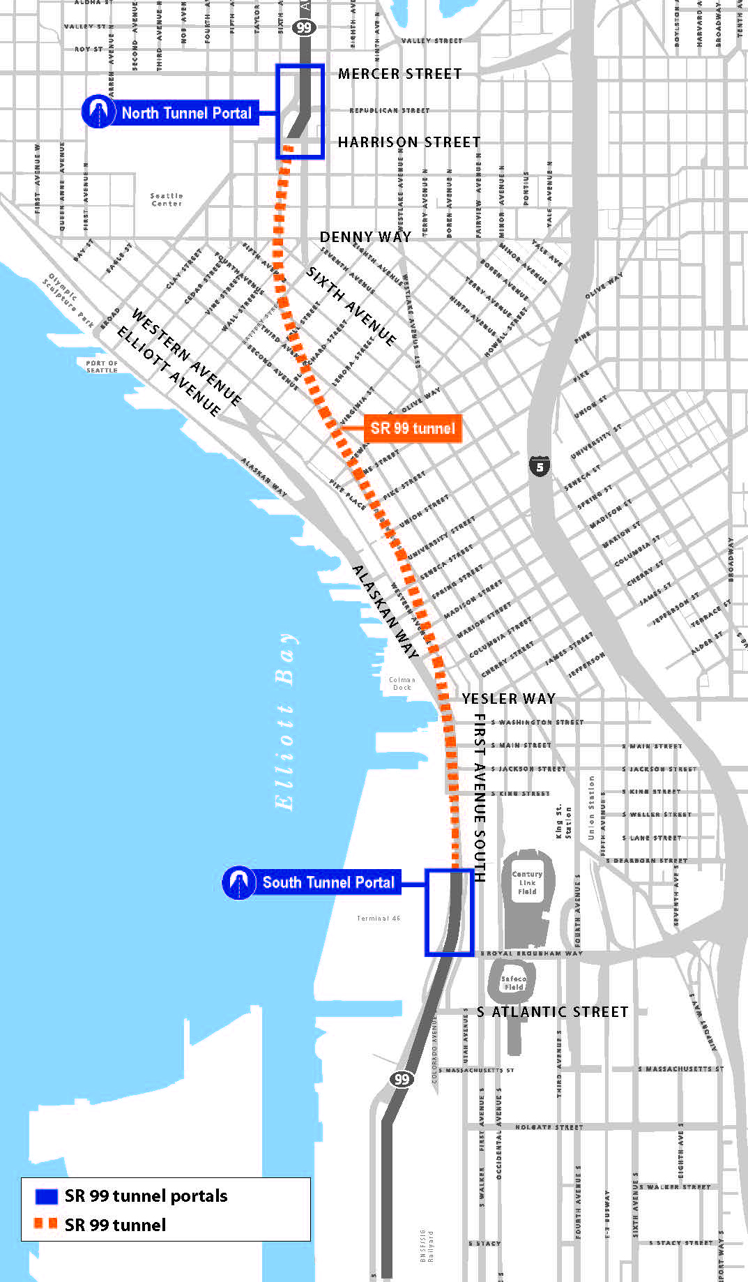
While the water main beneath Western Avenue was being replaced and groundwater monitoring continued, WSDOT crews had Bertha repaired and chugging along beneath the city, breaking into daylight near South Lake Union in April 2017. Seattle now awaits the opening of the tunnel Bertha cleared that will move traffic through the complex web of geology, hydrogeology, infrastructure, and development that makes up the Seattle waterfront.

WSDOT’s map shows the new Highway 99 tunnel through downtown Seattle to South Lake Union. Map credit: WSDOT

[1] Dewatering is the process of pumping water to keep an excavation dry.

Environmental Consulting Lessons Learned from the World of Analytical Chemistry

The story of environmental consulting projects often start with what the laboratory results tell us. However, all results are not created equal, and it’s important to know the big picture – site subsurface conditions, regulatory criteria, and chemistry principles – when uncovering culprit contaminants.

At one of Aspect’s recent, ongoing Technical Exchanges, Staff Scientist Andrew Yonkofski invited Mike Erdahl from Environmental Laboratory Friedman and Bruya to discuss the role of analytical chemistry in environmental consulting, including general petroleum chemistry, gas chromatography, and interpreting those results. Part of the discussion was focused on an Aspect-specific case study from a Seattle-area waterfront site. This site presents a unique look at how organic matter in the subsurface can affect results from the NWTPH-Dx analysis.

Lessons learned from the talk included:

  • Common petroleum hydrocarbon mixtures, such as gasoline and diesel, contain thousands of unique organic compounds. The NWTPH-Gx and NWTPH-Dx analytical methodologies attempt to capture the wide range of organic compounds found in petroleum hydrocarbon mixtures.

  • While the laboratory provides a reproduceable, quantifiable number for total petroleum hydrocarbon (TPH) results, those results often need to be interpreted in light of the chromatographic results. For instance, the higher boiling end of gasoline overlaps into the diesel-range. As the gasoline weathers, the proportion of material in the diesel range increases in relation to the total TPH value. Qualifying the diesel results as overlap from gasoline contamination can reduce the number of site-specific contaminant of concerns.

  • Likewise, results using both the NWTPH-Gx and NWTPH-Dx methodologies can sometimes include organic compounds from natural sources including degradation of organic material in the subsurface.

  • To properly characterize a site, environmental consultants must use multiple lines of evidence to determine the nature and extents of contamination. This includes interpreting analytical results and the associated chromatograms in the context of the historical site use.


This chromatogram illustrates how gasoline can overlap into the diesel-range. The diesel results reported by the lab do not indicate a separate diesel release from the gasoline release but rather illustrate how gasoline can overlap into the diesel-range as the product becomes weathered in the subsurface.

This example shows what a chromatogram may look like when there are multiple sources (both gasoline and diesel) present in a sample.

James Packman Talks Interdisciplinary Skills and Water’s Role in Urban Environmental Planning to UW Class

Senior Hydrologist James Packman recently presented to “Planning as a Profession,” a senior-level urban planning class in the College of the Built Environment at the University of Washington. The nearly 30 students come from different majors and career trajectories—among them are future architects, landscape architects, city planners, urban designers, real estate professionals, construction managers, engineers, environmental scientists, and more.

James Packman, Senior Hydrologist

James’ presentation, entitled “Environmental Skills, Water Resources, and Urban Planning,” gave a holistic view of environmental considerations in urban planning—from the skills and interests that lead a person to the profession and the different disciplines working in the industry to the laws and regulations that drive project design, permitting, and building and examples of water-focused planning. His overarching message focused on interdisciplinary skills, and he gave examples of Aspect projects where collaboration between disciplines was vital to address the environmental elements.

For example, the Waypoint Park project along Bellingham’s shoreline incorporated coastal geology, hydrogeology, stormwater management, civil and geotechnical engineering, landscape architecture, habitat restoration ecology, and more to reclaim a contaminated former industrial site to an urban waterfront park.

Waypoint Park Before and After Construction
City of Bellingham’s Waypoint Park incorporated many environmental planning steps to turn a former industrial site into an urban waterfront park.

James also introduced the practical side of business consulting, or how people and firms pursue and win public work, and walked students through the Request for Qualifications / Request for Proposals process. His key message for being on winning teams is that it requires networking in and outside of one’s discipline and forging relationships with public agency staff to learn their needs.

He ended by going over a homework assignment about the State Environmental Policy Act (SEPA) checklist process and its key role in urban planning projects. The homework reinforced the variety of environmental disciplines—geology, hydrology, archeology, botany, wildlife biology, engineering, and more—along with professional skills—technical reading comprehension, writing, project management, public speaking, quantitative analysis, and more—that are needed to complete the checklist.

James will present to a new set of students when he returns to the class in Spring Quarter 2019.